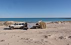
|
The Kimberley
|
|
|
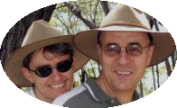
Heidi &Laurie |
 |
|
Kimberley Trip Pics |
|
| Part 1 | Part 2 | Part 3 | Part 4 | Part 5 |
| Painted Desert | Bungle Bungle | Lake Argyle | Cape Leveque | Gibb River Road |
Alice
Springs via the Flinders Ranges |
||
|
On a cold wet late May day in Melbourne, Heidi & Laurie plus
Heidi’s mother, Elsa headed north in our trusty Toyota Landcruiser plus a
hired T-Van from Guest 4WD for our 6 week adventure of the Kimberley in northern Western
Australia.
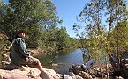
Our journey finally crossed the Murray River at Waikerie via the free ferry. After passing through Burra & Peterborough, we finally pulled up stumps at Hawker for the night. With the panoramic Flinders Ranges looking over our campsite, we headed north to Wilpena where Laurie & Elsa walked out to Hills Homestead & Wangarra Lookout while Heidi jumped on her MTB, and rode 35KM along the Mawson Trail to Brachina Gorge.
With a cold night expected in Brachina Gorge, we stoked up the
camp fire and studied the milky way overhead.
|
 |
|
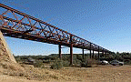 |
Lake Eyre via the Oodnadatta Track
We were now following the remnants of the old Ghan railway,
passing the famous Curdimurka & William Creek. After another cold night
under the stars, we headed north, stopping to revisit the Algebukina Bridge.
Built to cross the Neales River, this old Ghan bridge still stands high
above the flowing Neales river. After refuelling in Oodnadatta, we turned west towards the
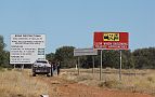
Stuart Highway. As we hadn’t visited the Painted Desert on previous trips,
we headed through the very scenic Arckaringa Hills (commonly known as the
Painted Desert). It was now time to move on Alice Springs. But at our overnight stop just south of the border, we were inundated with a mouse plague. Even though evasive action by Heidi by tucking her jeans into her socks, the little blighters still scrambled up her legs up onto her knees. All night, the hungry little devils scratched & nibbled around our tent, even climbing up the tent windows before falling back down. With the mouse plague passed, we nestled into the lovely MacDonnell Ranges caravan park at Alice Springs to refuel, restock & repair a couple of things. |
|
|
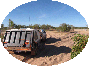
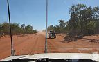
Kununurra via the Tanami Road 20kms north of Alice Springs, we turned onto the dusty corrugated Tanami Road. We were now heading to the real outback with no services. This road runs reasonably straight in a north west direction up to Halls Creek in northern WA. Approximately 1,000km in length, our last refuel at Tilmouth Well would mean we needed to carry 185Lt of fuel. The first 200kms was on a good bitumen road. After this, it was a wide dirt road with many corrugations. Our overnight stop on the side of the dusty track was peaceful with very little other traffic, apart from the occasional road train.
We eventually crossed the WA border & travelled further west
passing by Billiluna, (the start of the Canning Stock Route going south).
|
 |
|
 |
Heading into Wolfe Creek
After a refuel & to repair a tyre puncture in Halls Creek, it was time to explore the Bungle Bungle.
|
|
|
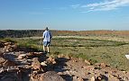
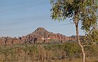
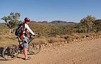
Purnululu National Park (aka the Bungle Bungle) After leaving the black top just north of Halls Creek, we endured a 53km dusty corrugated road with many river crossings to finally seeing the exciting Bungle Bungle. 2 1/2 hours later we arrived at the Walardi camp site. Walardi is situated near Cathedral Gorge, which is an easy 30 minute walk from the camp ground. The tall enclosed gorge is a must to see, with great acoustics. After checking out the views from Piccaninny Creek lookout, we headed north to walk through Echidna Gorge. Being there at midday, lets you view the gorge in total sunshine for about 10 minutes. After spending a lovely 2 days in the Bungles, it was time to move on. To keep up here exercise, Heidi jumped on her MTB and rode the 53kms out to the highway. Normally, a 2.5 hr 4WD drive, it took Heidi 4 hours to complete this picturesque ride out of Purnululu NP.
|
 |
|
 |
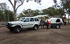
Kununurra - (the gateway to the Kimberley)
|
|
|
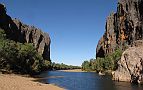
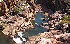
Visiting Lake Argyle The size of Lake Argyle is amazing. The concept to build a huge dam back in the 1970’s was a big task. With wet seasons to contend with, it added to the challenge to complete this man made dam within the confines of seasonal weather. Expected to take 8 years to fill – it only took 3. Spanning 65kms long by approx. 45kms wide, it holds a huge amount of water (no water restrictions up here!). Patrick Durack had to give up his pastoral lease for this to go ahead. Sadly, the site of his homestead is now covered by the Lake.
It was great to see the lake so full, after the record high
rainfall from this year's season.Lake.
With warm sunny weather, & calm waters, we ventured out on a sunset
cruise of the lake. A 4 hour pleasure, seeing many crocs (fresh water) as
well as wild animals living on the islands scattered throughout the lake.
|
%20dam%20wall%20.JPG) |
|
 |
Travelling the Duncan Hwy
|
|
|
Wonderful Windjana Gorge Heading back to the dust, it was time to don our budgie smugglers & walk through Tunnel Creek, The creek runs through a dark 500 metre tunnel, requiring caution as you put faith in your trusty torch to show you the way through the cool creek water. With the water coming up to our waist in places, we finally made it through to see the lovely scenery on the 'other side'. Retracing our steps was just as eerie, as we passed torch lights of many other travellers heading through the watery tunnel. Heading further north, we arrived at Windjana gorge. Full of fresh water crocs, some travellers were prepared to get up close & personal with some of these cold blooded reptiles. The 'not so foolish' walkers headed down through the very scenic gorge for the 7km return walk.
|
 |
|
 |
Heidi, who needed some exercise, dusted down her MTB & road out
of camp along a very corrugated Windjana Rd to the intersection of the Gibb
River Road. With some bitumen in site, we secured the MTB & headed for Derby
to visit the old Prison Boab tree. I am not sure I would have liked to spend
time locked inside the tree, but it certainly enticed many tourists in 4WDs
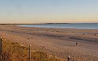
& 2WDs to see this historical tree. Visiting Broome Broome was next on our list, so a couple of nights were spent at Cable Beach viewing the lovely sunset as well as a power walk along the sandy shore.
|
|
|
Cape Leveque - north coast With some necessary repairs & food restocking, it was time to head north to Cape Leveque. A 100km very corrugated dusty red soil road greeted us, as well as a protest group demonstrating against a gas pipeline on the Cape. They were quite peaceful & let us travel through their demonstration. One Arm Point (right at the top of the Cape) was a lovely place to visit - with great views over the archaepelgio, & an eleven metre swirling tide, plus of course those nasty little 'hard to see' sand flies - also watching the turtles swimming at the Trocus shell farm was a thrill.
|
 |
|
 |
Cape Leveque - west coast Bush camping at Gamlamban (near One Arm Point) on a full moon added to our trip's highlights. Returning south, to restock, our travels took us to Middle Lagoon - set on the coast with a rugged red coastline plus a sensational pristine white sandy beach. After passing through the protester group again, we clung to the coast & spent a very peaceful night at Cape Boileau, camping on the sand in front of another magical sandy beach.
|
|
|
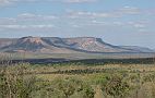
The Gibb River Road After retracing our steps to Derby & celebrating Elsa's birthday, we finally began the dusty corrugated Gibb River Road in earnest, visiting Lennard River Gorge with its magical 2 tiered waterfalls, viewed from high up on the cliff face. Silent Grove was our next encounter, which is close to Bell creek. This creek falls down through Bell Gorge, one of the most fascinating gorges we visited. For 4 hours we walked, snapped some pics, climbed & swam the gorge just below the graceful waterfall.Mornington Wildlife Reserve was a little further down the Gibb River Road. With a 2 hour drive to the homestead, lovely views can be seen of the Kimberleys as we headed south towards the Fitzroy River. Heidi was back on her MTB as we drove the 25km through some creek crossings to the picturesque Dimond Gorge.
|
 |
|
.JPG) |
Mitchell Falls - the highlight of our trip! After visiting the interesting Adcock Gorge & waterfall, we pushed on to Mt Barnett to refuel at $2.05/Lt (our most expensive fuel purchase). Manning Gorge was our overnight stop, so we donned our swimmers and walked the 4kms into the Gorge for a refreshing swim on our own under the waterfall. With the Kalumburu Road partly open, we crossed the Gibb River & headed north. Although corrugated & rough in places, we finally made it to the Mitchell Falls campground where we stayed for a couple of nights.
The 4km walk to the falls was enjoyable in the cool of the early morning
sunlight. We left camp at 7am and were at the falls an hour later. The walk to the
falls was enjoyable. To reach the falls, we needed to walk through the Mitchell River at knee height
for about 50 metres. Laurie
managed to slip on a loose rock and almost drown his camera. |
|
|
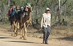
Finishing the Gibb River Road Atfer retracing our steps to the Kalumburu turnoff, we passed a guy with his 2 camels walking up to Mitchell Falls - that's an interesting way to see our great country! Continuing along the Gibb River Road, we stopped for our last night at Home Valley where we met up with some of the staff we met at Lake Argyle 3 weeks earlier. We were soon back in Kununurra which Mobile Phone reception. We soon learned from our security company, monitoring our house, that we had a power cut 7 days earlier. After a call to our neighbours, we ascertained there was an internal issue with the power that could not be resolved from outside. Heidi's mother offered to fly home & sort the problem out. Flights were organised and Elsa was back in Melbourne that night. Apart from a faulty timer switch & losing our freezer & fridge items, no other major issues were found.
|
 |
|
 |
Heading Home Our trip was coming to an end. All that was left was the 4,000 km drive home. 7 days of driving and readjusting to very cold nights & days makes us want to turn around and go straight back to one of Australia's most fascinating places to visit. The Kimberleys are a must to see! Roll on next year's annual leave! |
|
|
|
||